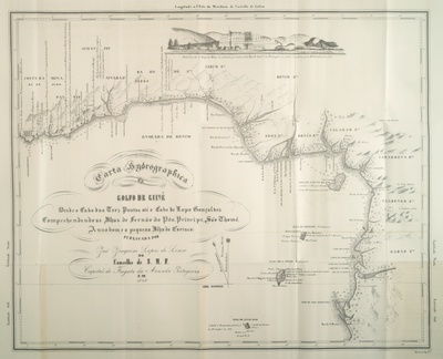
Image Detail
The Bight of
Benin is probably one of the most well known regions engaged in the transatlantic slave
trade. The Portuguese called the entire African coast between Cape Palmas and Gabon,
including the bights of Benin and Biafra, the Gulf of Guinea. This large coastline
included places known to the people engaged in the slave traffic as the Slave Coast or the
Coast of Mina, where Elmina Castle was located (in present day Ghana). The image is of a
map of this area published by the Portuguese Commander José Joaquim Lopes de Lima in 1845.
It provides the names of the main rivers of the region and locates several European forts
built on the coast as well as the major African polities located in the immediate interior
of the continent. In the upper section, the map also has an illustration of Elmina Castle.
In the 1840s, despite the fact that the slave trade was illegal, many vessels continued to
depart from this region with slaves destined for the Americas. The image is reproduced
courtesy of the Manuscript, Archives and Rare Book Library, Emory University.
Metadata
|
Year
|
1845 |
|
Source
|
J.J. Lopes de Lima, Ensaios sobre a Statística das Possessões Portuguezas... (Lisbon, 1844-62), vol. 2, part 2, on the back of p. 48. |
|
Language
|
Portuguese |
